 |
| MOUNT TABOR FROM THE SOUTHWEST. |
| Page 304. |
|
[Table of Contents] [Previous] [Next] |
J. W. McGarvey Lands of the Bible (1881) |
C H A P T E R V I.
PLACES ABOUT THE PLAIN OF ESDRA'ELON.
§ I.
ON THE EASTERN BORDER.
WE have given a geographical description of the Plain of Esdra'elon and the adjoining plains in Chapter I., § V., Part First. We are now to speak of the villages, mountains, and other interesting localities in the same district.
The only town of any importance at the present day on the Plain of Esdra'elon is Jenîn', the ancient En-Gannim (garden-spring), a city of Issachar, which was given to the Levites.1 It is situated at the southeast angle of the plain, at the foot of the hills which rise to the east and southeast of it, and at the mouth of a pass between the mountains southward, through which must always have led the principal thoroughfare from the plain and all Galilee. Jesus must often have passed by it, though it is never mentioned in connection with his journeyings. Though it scarcely has a Bible history, it is mentioned in the writings of all modern travelers, because, as above stated, it is the only town of importance in a large district, the ancient cities which once overshadowed it having gone to ruin. It contains about 3000 inhabitants, and is the seat of a subordinate Turkish governorship and a garrison of soldiers. It is well built of stone houses, and is surrounded on the south and west by luxuriant gardens of vegetables and fruits, with an occasional palm-tree. A copious and perennial stream, whose source is in the hill to the southeast, is brought by an underground stone conduit to an artificial basin in the lower or western edge of the town, where it stands in a crystal pool about 6 feet long, 3 wide, and 18 inches deep. Here the women of the town are constantly coming, lingering a while to chat, and going, while well-dressed and clean-looking men sit or loiter about in the shade. Below the pool the surplus water passes in a stream 2 feet wide and 18 inches deep into a stone watering-trough about 30 feet [298] long, where animals of the town and of all passers-by are freely watered. Hence it is led into irrigating channels for the gardens below, and can be all turned at pleasure into an elevated stone channel to a mill in the edge of the gardens. A mosque kept in unusually good repair stands in the western edge of the town. On its southern side is a garden of figs and pomegranates, and along the northern a long portico with arched praying-places, while two pools of limpid water stand ready for the sacred washing of hands, feet, and face which must precede every prayer. The white minaret of the mosque is a conspicuous object from every direction to those traversing the plain.
About seven miles a little east of north from Jenîn' is the village of Zerîn', the ancient Jez'reel, which gave its name to this entire plain. The road thither is along the foot of the mountain which rises to the east, and on ground slightly elevated above the plain to the west. In places we see remains of the ancient pavement. There is a gradual ascent all the way from Jenîn'. Five or six villages are seen on the right, and two or three on the left. Jez'reel was most delightfully situated. While the ground slopes away gently toward the south, it slopes more abruptly toward the east until it reaches the level of the plain, and the view from the south toward the west and around to the north takes in the entire Plain of Esdra'elon, with the mountain-rim which bounds two sides of its triangle. Almost due west, and 16 miles distant, is distinctly seen the place of Elijah's sacrifice on Mount Carmel, and when Ahab was returning to Jez'reel from that stirring scene, followed by the black clouds of the coming rain, and preceded by the rugged form of Elijah, his chariot could be seen from the walls of Jez'reel every foot of the way.2 To the northwest the almost perpendicular mountain wall which shuts off Nazareth from the view is only seven or eight miles distant, and a white house recently built on a hill overlooking Nazareth is distinctly seen. To the north, about four miles distant, is Jebel Dû'hy (Little Hermon), which rises so high as to hide from view Mount Tabor, which stands behind it. To the east is the long Plain of Jez'reel, continually widening as it recedes; and to the southeast is Mount Gil'boa, on the long northwestern spur of which Jez'reel stands. The present village is a collection of miserable huts, but into the walls of these are built many pieces of ancient masonry. The most conspicuous object is the ruin of an old church, a part of whose wall stands 20 or 30 feet high. The surface about the village is covered with ancient building-stones, and rock-cut cisterns are very [299] numerous. The author counted five of these within an acre of ground. A large limestone sarcophagus lies half buried a little south of the village.
Ahab showed taste and judgment in selecting this as the site of his summer palace, to avoid the heat and the contracted view of his capital at Samaria. And Saul's army, when posted here before his last and fatal battle, had an admirable defensive position against the Philis'tine host drawn up at Shunem, on the opposite slope of Jebel Dûhy. Immediately in front of Jez'reel to the north there is an almost perpendicular descent of 400 feet into the Valley of Jez'reel, up which the Philis'tine army would have to clamber in making an attack on Saul. Shunem is on the opposite edge of this valley, but almost as high as Jez'reel, the valley sloping rapidly down from it to the foot of the Hill of Jez'reel.
From Jez'reel there is a very good view of Mount Gil'boa. The western and northern sides of this mountain come together here at an acute angle. The western side stretches off in a direction nearly due south to the vicinity of Jenîn, while its northern side runs in almost a straight line south by southeast until it suddenly breaks down into the Jordan Valley, about 12 miles distant. This northern--or, more strictly speaking, northeastern--side is almost perpendicular, while the western has a gradual slope. Its highest elevation, which it attains in a point but a short distance southeast of Jez'reel, is 1717 feet. Saul and his men were doubtless retreating over the slopes of this mountain when he and his sons were slain.3
The author and his party rode from Jez'reel eastward down into the valley, and along the northern base of Mount Gil'boa, on their way to Beisan'. About two miles from Jez'reel we crossed the stream of Ain Jalûd', supposed to be the Fountain of Harod mentioned in connection with Gideon's attack upon the Midianites,4 but incorrectly called a well in the English version. It is a bold stream of water, 20 or 30 feet wide and a foot or more deep, issuing from a cave-like recess in the rock of the mountains base. The water is cool and clear. It is so dammed up a short distance below as to make it spread out into a wide pool, and farther on it is led into irrigating channels and makes verdant a large portion of the valley. About three miles farther east another spring issues from under a ledge of rock 100 or 200 feet from the base of the mountain, and a dam thrown across the depression below it swells its water into a beautiful pool about 100 yards long and [300] from 20 to 30 wide, with a depth of from 8 to 10 feet. So perfectly transparent is this water that the smallest object can be seen distinctly at the bottom of it, which is covered with white pebbles. When the author first drew near it he mistook the white bottom for a white scum on the surface, and was equally surprised and delighted, on reaching the edge of the basin, to see it eight feet below the surface. His company enjoyed in this limpid pool the most delightful of many delightful baths which they took in the waters of Palestine. The temperature of the air was 97° in the shade of our umbrellas, and that of the water precisely the degree to be most refreshing. The water of this spring turns a mill which stands below the dam just mentioned, and then runs away, like that of the one above, to irrigate the fields and pastures of the plain.
About 12 miles east of Jez'reel is the modern village of Beisan', answering to the ancient Bethshe'an, the ruins of which are very extensive, full of interest, and many of them well preserved. The site of the original city, and of what we might call the acropolis at a later period, is the summit of an isolated hill which once formed a continuous part of the cliff overlooking the Jordan Valley, but is now cut away on both sides by two deep chasms, through which, on each side, flows a stream of water. These are the streams which flow from the two springs mentioned above in the plain of Jez'reel. The heads of the two ravines are about a quarter of a mile west of the hill in question, and between them for that distance is a valley but a few feet above their level. After passing by the hill they come together east of it, and thence flow as one stream to the Jordan. The hill thus cut off is about 100 feet higher than the level of the plain, and its summit is crowned with an ancient wall six or eight feet thick, which passes entirely around its brow. On its northern slope is a plateau about twice as large and about 100 feet lower, which is also surrounded with a wall, and has a gateway at the northwest corner. A large and deep cistern, whose arch is partly broken, is seen a short distance from the gate, and a zig-zag roadway, now impassable, led from the gate to the valley on the west. The sides of this hill are everywhere so steep as to be ascended only on foot, and by a path winding half-way around it. From the western brow of this acropolis one looks down in the valley below upon a confused mass of stone walls; standing and prostrate columns; an ancient Roman theatre, well preserved; long stretches of street pavement laid with heavy blocks of basalt; bridges of the same rock spanning the two streams; and two modern water-mills, propelled by the streams where they break down from the [301] higher level of the plain. These are the ruins of ancient Bethshe'an. Other ruins are scattered about over a large area on the high plain immediately south of this valley. Lifting the eye from these ruins, and taking in the more distant view, the long plain of Jez'reel lies before us, coming almost to a point in the distance where the sides of Mount Gil'boa and Jebel Dû'hy approach each other, but having a narrow gap at the farthest extremity, between Jez'reel and Shu'nem. Through this gap can be distinctly seen, though 28 miles away, the eastern end of Mount Carmel, where Elijah called down fire from heaven. If we turn around and look to the eastward, the Jordan Valley, 500 feet below, stretches away to the north and south for many miles, while the lofty mountain range beyond the Jordan bounds the entire horizon in that direction. It was probably on the wall of this acropolis that the bodies of Saul and his sons were gibbeted by the victorious Philis'tines, who had found them the day after the battle, just yonder on the slopes of Mount Gil'boa. And hither came the men of Jabesh-Gilead, from the mountains yonder beyond the Jordan, took down the bodies, bore them in triumph to their own city, and burned them to prevent their recapture and further mistreatment. Thus they expressed their gratitude to Saul for that wonderful deliverance which he wrought for them in the beginning of his reign.5
The main road from She'chem and all southern Judea to Damascus passes through Beisan', and, descending here into the Jordan Valley, crosses the Jordan at the Mejami'a bridge, about 12 miles to the northeast.
Returning now to the head of the valley, we visit Shunem, now called Sulêm', already mentioned as being about four miles due north of Jez'reel, and situated on the southern slope of Jebel Dû'hy, near its western end. It is noted partly for its connection with the battle of Mount Gil'boa, in which King Saul lost his life, but chiefly as the home of the good Shunammite woman who befriended the prophet Elisha and was so amply rewarded.6 It was also the native place of Ab'ishag the Shunammite.7 It was never a place of great importance. It is now a small village of huts. The view from it to the west embraces the entire Plain of Esdra'elon, and the eye can trace the line of the Shunammites ride of about 16 miles when she went after the prophet on the death of her son. The sloping valley immediately south of the village is probably the field in which her husband was harvesting when the child was smitten with sunstroke and sent to its mother. [302]
The mountain called Jebel Dû'hy is 1815 feet high, about 100 feet higher than Mount Gil'boa, and on its highest summit is a Mohammedan wel'y, whose whitewashed surface is a conspicuous and striking object from every direction in which the mountain is seen. It is the tomb of the prophet whose name the mountain bears, but who he is explorers have not ascertained. There is a small village near the wel'y. This mountain was supposed at one time by the Crusaders to be Mount Hermon, and for a time it was so called. When the mistake was discovered they called it Little Hermon, and so it has often been called since. Although it is more conspicuous than Gil'boa, and almost as much so as Tabor, and has on its base in different places three well-known villages, yet it is not once mentioned by name in the Bible.
The other two villages just referred to are Nain and Endor, both on the northern slope of the mountain, the former about two miles from the western end, and the latter about two miles farther east. Nain is perched on a bench, with a steep slope of about 60 feet descending to the plain just north of it. The road from the north approaches it by a narrow valley at its western end, and beyond this are some rock-cut sepulchres with loculi in them of both kinds. As Jesus approached the gate of the town, coming from the direction of Capernaum, where he was the previous day, the procession bearing the son of the widow was going out toward this burying-place, and thus they happened to meet. It was probably late in the afternoon, as the distance from Capernaum is more than 20 miles by the nearest route.8 The village is a very small one, containing only a dozen or so small huts, but around it are scattered the ruins of better buildings, and on the brow of the westward steep are the remains of what may have been the town wall. The expression "gate of the city," used by Luke, implies that it was walled when visited by Jesus. Among the ruins are those of a small church. The Latins have obtained control of this, and when the author was there workmen were about to commence the reconstruction of it, under the direction of a priest who had pitched a tent near the spot.
Between Nain and Endor, two miles farther east, there is a gap in the mountain which passes entirely through it, although it rises to a considerable height midway. By this King Saul came over from his camp near Jez'reel the night before the battle to visit the Witch of Endor. As the Philis'tine army was immediately north of him, he had to pass by its left flank in order to make the perilous excursion,--a [303] venture which he would scarcely have made had he not felt himself in a very great strait.9 The village still wears its original name, pronounced by the Ar'abs Endûr', and it is perched on a steep rocky slope pierced by many caverns, at least one of which is inhabited. The population numbers about 150 persons, and the supply of water is from a feeble spring in a cave above the village. It was nearly dry when the author saw it, and it was kept in so filthy a condition that, although thirsty, we did not try the quality of its water.
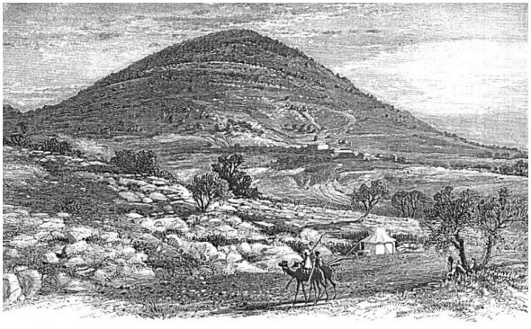
Directly north of Jebel Dû'hy, and distant about five miles, across a lovely plain which declines toward the Jordan, rises the majestic form of Mount Tabor, 2000 feet high, and almost in the shape of a cone. Our engraving of it shows it from the southwest, and is not the most pleasing view, the connecting ridge toward the west giving it a somewhat tilted appearance, which it does not present when seen from almost any other direction. From that ridge, which is about 200 feet high above the plain and connects the mountain with the hills toward Nazareth, the ascent is made to the summit up a very steep, winding, and rocky path. The highest point of the summit is near the eastern part of the mountain, and there a considerable area is inclosed by the remains of an ancient wall with a moat outside. Robinson quotes Polybius as saying that Anti'ochus the Great, 218 B. C. took a city which then stood here and fortified it.10 Josephus, the historian, also fortified the place at the beginning of the Roman war, and we enter the area inclosed by the walls through the ancient gateway on the western side.11 From the top of the wall at the southern side is obtained a magnificent view of the plains and mountains to the south. Within the walls, near the same spot, a broad space of naked rock is drained during the winter rains into a cistern in its centre, which affords a drink of cool and pure water. Farther to the east are two monasteries, the Latin on the south and the Greek on the north, about 200 yards apart, with a new stone wall separating their premises. These have both been erected since Robinson's visit in 1838 (see II. 352, 353), and they are intended to commemorate the transfiguration, which, from the time of Jerome in the fourth century until within the last few years, was supposed to have occurred on this mountain. It is said that three churches were built here during the Christian period of Palestine to commemorate the three tabernacles proposed by Peter. Mark and Luke say that Peter knew not what to say, because he was frightened, when he proposed these tabernacles, and it is quite evident that those who built [304]
|
| MOUNT TABOR FROM THE SOUTHWEST. |
| Page 304. |
the three churches knew not what to do; their folly far exceeded that of Peter, and they had not half so good an excuse for it. Many other structures were alternately built and thrown down during the conflicts between the Christians and Saracens.
While the southern side of Mount Tabor is entirely bare of trees and shrubbery, the northern side is covered with a dense growth of brushwood, mostly oak, and the long slope near its base12 is thickly set with the finest grove of oak-trees in Palestine. Many of them are from two to three feet in diameter, but their trunks are too short to be very valuable except for firewood and such mechanical purposes as require only short pieces of timber. The limbs are large, and many of them sufficiently straight to furnish wood for similar purposes. There is not a "rail cut" in all the forest.13
From Mount Tabor to Nazareth is about six miles, a little north of west, by a very direct road; and to Tiberias, the nearest point on the Lake of Galilee, is about 10 miles.
The only village close about the mountain is on the southern slope of the connecting ridge or saddle on the west. It is called Debûrî'eh, and is identified with the Dabe'rath which was on the line between Zebulon and Issachar; was given to the latter tribe, and afterward to the Levites.14 It has the remains of a church and some other ruins. It is seen in our cut.
Some two or three miles west of this village, at the foot of the precipitous bluff up which the road from She'chem to Nazareth climbs, is the small village of Iksâl', the Chesulloth mentioned in Joshua (xix. 18) as on the line between Issachar and Zebulon.
The only place of interest remaining yet to be mentioned on the 12
eastern border of the great plain is Fû'leh, noted as one of the battle-fields of Napoleon Bonaparte during his Syrian campaign of 1799. Marshal Kleber, with 1500 men, was here attacked by 25,000 Syrians early in the morning of April 16th, and after a desperate fight of six hours was relieved by Napoleon himself, who, anticipating the attack, rushed out from A'cre, which he was besieging, with only 600 men, reinforced his marshal about noon, and put the Syrian army to flight. He supped that night in Nazareth. This town is in the plain, nearly west of Shunem, and on the road from She'chem to Nazareth. The battle is called the "Battle of Mount Tabor." [305]The northern and southern borders of the Plain of Esdra'elon are singularly void of interesting localities, especially of such as have a name in the Bible; while the plain itself is too wet in winter and too dry in summer for the erection of towns. The tillers of the northern portion live in villages, for the most part hid in the Galilean hills, and those of the southern portion are equally hid among the hills of Samaria, where they enjoy a purer air, better water, and greater security from the Bed'awin, whose frequent incursions into the plain in former years rendered life and property unsafe. Not a single town of importance is identified along its northern border, either on the plain or in the adjacent hills, with the exception of Iksâl' and Debûrî'eh, already mentioned.
§ II.
ON THE SOUTHERN BORDER.
In order to obtain a conception of localities in the southern border of the plain, it is best to return to Jenîn', at the southeast angle, and follow the road which leads thence along this border to Mount Carmel, Haifa, and A'cre. After traveling about seven miles from Jenîn', we pass a ruin-covered mount called Tell-Ta'anuk, which answers to Ta'anach, a city which was first allotted to the tribe of Issachar, but was afterward given to Manasseh, and finally occupied by Levites.15 The battle in which Ba'rak defeated the army of Sisera extended into its territory.16
About four miles northwest of Ta'anach, and eight miles southeast of Mount Carmel, is the ruin called El Lejjûn', a corruption of the Roman name Legio, which, in its turn, was a corruption of Megiddo. This, throughout the chief part of the Old Testament period, was the most important city on the borders of the great plain, Jez'reel alone having eclipsed it in importance, and only for a short time. It was one of the cities which Solomon selected for his system of national fortifications,17 doubtless because it commanded the chief line of march between the Plain of Sha'ron and the Plain of Esdra'elon. Armies passing through the country from north to south, or from south to north, always sought the advantage of these two plains. When Pharaoh Ne'cho was making this passage on his way from Egypt to the Euphrates, Josiah attacked him here, and was defeated and slain.18 It is [306] situated in a small circular valley almost surrounded by hills,--a kind of bay to the great plain. A stream of water, a tributary to the Ki'shon, runs across the northern edge of the valley, and is crossed on an ancient stone bridge built for the thoroughfare mentioned above. Three mills are propelled by the stream ere it reaches the level of the Plain of Esdra'elon. The principal ruins are those of a very large and strongly-fortified khân, a short distance south of the bridge, whence the place takes its modern name Khân el Lejjûn'. A similar but smaller and more ancient ruin covers a hill just north of the bridge. These ruins are all of more recent date than Solomon's fortifications, but they may be composed partly of stones used by him, and excavations might reveal some of the foundation walls which he laid.19
North of Lejjûn', projecting out into the edge of the Plain of Esdra'elon, is a very remarkable hill, which is the most conspicuous object on this border of the plain except Mount Carmel. It is about 200 feet high, its sides are artificially worked into two high terraces, and its top, which is about half a mile wide and a mile long, appears to have been artificially leveled. Its commanding position, the vast amount of labor which has given it its artificial form, and its propinquity to the reputed site of the town of Megiddo, all combined to suggest to the author the question whether it is not the real site of Solomon's fortification. It would certainly be far better suited to the purpose than the comparatively indefensible site of Lejjûn'.
In our progress northwestward we next come to Mount Carmel, whose southeastern extremity is near the terminus of the Plain of Esdra'elon. A short distance from it westward, the hills of Galilee, which make a long curve to the southward around the western end of the plain, terminate in a bluff about a mile from the side of Mount Carmel, leaving a pass which has a downward slope into the Plain of A'cre. Through this the Ki'shon flows into the latter plain.
Mount Carmel is a ridge 14 miles long, extending from near the northwestern angle of the Plain of Esdra'elon, northwest to the sea-shore, where it drops down suddenly, leaving a narrow beach at its foot. It is 556 feet high near this extremity; 12 miles farther inland it attains a height of 1810 feet; and toward the other extremity it makes a slight descent, being there only 1687 feet high. Its northern side runs in nearly a straight line, and rises like a wall from the [307] edge of the adjoining plain. On the other side it runs out into spurs descending into the Plain of Sha'ron. These are long at the southeastern end, but they grow shorter as the sea is approached, thus imparting to the entire block of the mountain the shape of a triangle, with its apex at the sea-shore. The mountain is nearly everywhere covered with a thick growth of brushwood, and was once extensively cultivated and studded with many villages; but Ibrahim Pasha, in 1837, destroyed all but two of the villages, and the cultivation ceased. The brushwood has grown up since that time.
At the eastern extremity of the mountain there is a place on its summit called El Mah'rakah (the Place of Burning), from the supposition that here Elijah called the fire from heaven to consume his sacrifice.20 Many ancient ruins are scattered about, some of them overgrown with young oaks, and in the midst of them is a rock-cut pool for rainwater about 35 by 20 feet and from 6 to 8 feet deep. Near the eastern brow of the eminence stands a low stone building of comparatively modern date, in which the Latins sometimes celebrate mass. The view toward the east includes the entire Plain of Esdra'elon. Mount Gil'boa, with Jez'reel at its foot, is in full view, as is also Jebel Dû'hy, with Shunem at its foot; while the conical top of Mount Tabor is seen peering over the hills to the south of Nazareth. The view to the west is shut off by the higher part of the mountain in that direction, but by going less than 100 yards back from the brow of the mountain we can see over the southern slopes of its spurs down to the sea-shore, and the Mediterranean is distinctly visible for many miles above Cæsarea. This is the view obtained by Elijah's servant when the little cloud was seen hanging over the sea, and the summit occupied by the ruins above mentioned is the prophet's place of prayer, and not his place of sacrifice. From the latter place Elijah "went up to the top of Carmel" when he went to pray, and from the praying-place he sent his servant seven times to look toward the sea for signs of rain.21 We are to look elsewhere, then, for the place of sacrifice, and it must be a place of greater area than this narrow summit, in order to have accommodated the vast multitude who were present. But here it is, immediately in front of us to the east, and 300 feet below us. It is a plateau sufficiently broad for the assembly, and reached by roads which ascend the slopes of the mountain from various directions. By dismounting and leading our horses we managed to descend to it, having reached the summit by a different route. The plateau answers in every particular [308] the demands of the narrative, even to the possibility of Ahab's chariot ascending to it,22 and there is no other on the mountain that does. Even the matter of procuring the water which was poured on the sacrifice (verses 33-35) is provided for. It could not have been obtained from the Ki'shon, which is 1400 feet below, and half a mile from the foot of the mountain, and was also dry after the three years of drouth, but from a spring in a well some 10 or 15 minutes' walk down the slope toward the north. This well, mentioned by all visitors to the spot, had an abundance of good water when visited by the author, although the Ki'shon, just opposite, was entirely dry, thus proving that the well is more unfailing than the river. Though the river must have been dry at the time of Elijah's great victory here, a heavy flood of rain was about to fall, and the bodies of the 400 prophets of Baal, which he caused to be cast into the bed of the stream, were soon washed away by the rising current.23
On the opposite extremity of Mount Carmel, overlooking the sea, is a large and well-built monastery belonging to the Carmelite monks of the Latin Church. It has rooms for 30 monks, though it usually contains only about half that number, and it has accommodations for about 30 guests. The present building was founded in 1828, its predecessor having been burned by the Pasha of A'cre in 1821. This was but a repetition of similar disasters which have marked the history of this convent. The hermits for whom the first building was here erected were organized into a company, in the year 412, by the Bishop of Jerusalem. Four times since the beginning of the twelfth century have the buildings been destroyed and the monks all massacred. During the siege of A'cre, in 1799, Napoleon used the monastery for a hospital. After his retreat the sick and wounded soldiers who were left in the monastery were all butchered by the Moslem. Their bodies were buried in front of the building, and a rude stone pyramid, erected by the French government and bearing a suitable inscription, now marks the spot.
§ III.
ON THE PLAIN OF A'CRE.
At the foot of Mount Carmel, on the north, lies the Bay of A'cre, a semicircular sheet of water whose radius is about three miles, and which is protected from southwest winds by the mountain. To the [309] east and north of the bay, the Plain of A'cre stretches away some nine or ten miles, bounded on the east by the hills of Galilee, and on the north by the mountains of Phœnicia. The view over this bay and plain, from the convent on top of the mountain, is exceedingly beautiful. Immediately at the foot of the mountain lies a level and fertile plain, about a mile and a half wide, occupying the space between the mountain and the bay. It reaches from the Mediterranean on the west to the city of Hai'fa on the east, a distance of about three miles. Across the bay, in the angle which it makes with the sea, stands A'cre, white and pretty in the bright sunshine, while the entire plain, with its margin of mountains, forms the background of the picture. We descend from the convent to the Plain of Hai'fa, about 600 feet below, by means of a new road, which has been cut by the monks along the northern slope of the mountain. The road is straight, and descends toward the east with an easy grade.
On reaching the plain we are in the edge of the German settlement, which is a well-built European village of 300 inhabitants, lying at the western side of the old Arabic town of Hai'fa. The houses are of stone, but they have sloping roofs covered with tiles, and every house is surrounded by a yard and has a garden in its rear. The village boasts a good hotel, a church, and a school-house. The inhabitants are of the same faith with the Germans at Joppa; they have all the mechanic arts among them, a wind-mill, a tannery, an olive-press, and, what is most remarkable, an American steam threshing-machine, the only one in all Asia. They have two-horse wagons, and, although the horses pull by rope traces, the entire outfit has a homelike appearance to the traveler from America. They cultivate nearly 1000 acres of land lying in the narrow plain west of their village, 100 acres of which are in gardens and vineyards. Their vineyards are chiefly along the slope of Mount Carmel; they are well walled, the ground is terraced, nice walks lead through them, and they everywhere bear marks of thrifty culture and good taste. The wine manufactured from them is of good quality, but it has not proved as great a source of profit as the settlers once hoped it would. The old town of Hai'fa shows marks of improvement, the result of contact with the superior civilization of the German village. It is well built of white limestone, with some new houses in course of erection, and it has an appearance of neatness quite unusual in the towns of Palestine. Its population numbers about 4000, of whom one-fourth are said to be Jews, and one-fourth Christians. A portion of its ancient wall still stands at the eastern end of the town, and an old dismantled castle [310] stands on a bench of the mountain south of the town and overlooking it. It is one of the two places in Palestine where steamers land (the only other is Joppa), and it is one of the three which have a post-office, Joppa and Jerusalem being the other two. Its commercial importance, due to its partly-sheltered harbor, has not only led to these advantages, but has caused it to become the seat of several European sub-consulates, and their flags wave gracefully over the town. Among the others, it is pleasing to American eyes to behold the Stars and Stripes floating from a mast in front of a house where dwells the representative of the American government. The regular steamers of the Austrian and the French mail-lines stop here on both their upward and downward trips along the coast, and they furnish between them two mails per week. Persons in the interior who write letters send them hither, or to Joppa, by private hands to be mailed. The steamers, however, are compelled, on account of shallow water, to cast anchor a considerable distance from the shore. The town of Hai'fa, important as it now is, is not once mentioned in the Bible.
The road from Hai'fa to A'cre (12 miles) passes around the curve of the bay, following the beach, which is smooth and level. The German wagons of Hai'fa make regular trips between the two towns, bearing passengers and parcels. At a distance of about two miles we cross the mouth of the river Ki'shon. Its current, after it enters the Plain of A'cre, is sluggish, though its volume is much increased by springs from the base of Carmel, and it finds its way with difficulty into the shallow bay. The westerly winds blow the sand into its channel and push back its waters, so that only when the current is strengthened by rain, and favored by an easterly wind, can it cut a clear channel into the bay. Just at the mouth it is narrower and more shallow than farther back in the plain, where its usual width is about 30 yards, and its depth often too great for fording. All about it is the most luxuriant vegetation, with palm-trees rising majestically above all the other growth.
About seven miles farther, or nine miles from Hai'fa and four from A'cre, is the mouth of the river Be'lus (Nahr Namein), a stream which flows across the plain from the hills and is nearly as large as the Ki'shon. It is not mentioned in the Scriptures.
After crossing the Be'lus, the road soon turns with the beach toward the west, and enters A'cre through a gate near its southeastern corner and close to the shore of the bay. This is the only gate of the city. From the gate northward to the northeast angle of the town, and thence westward to the shore of the Mediterranean, is a new wall, not high, but built on the most approved modern plan, with [311] earth-works to protect its artillery, and mounted with new and heavy guns. A deep and broad moat outside this wall seems intended to be filled with water in case of a siege, thus rendering the town almost unassailable from the land side, while the shallow water all around the two sea sides prevents the near approach of large vessels. The defenses seaward are in a state of dilapidation. A strong garrison occupies the citadel, and visitors are not allowed to examine the defenses from the interior.
A'cre is the Accho of Judges i. 31, out of which Asher, to whom it was given, could not drive the Canaanites. It has no other history in the Old Testament, but it is the Ptolemais of the New Testament, at which Paul stayed one day on his last journey to Jerusalem.24 This latter name, derived from Ptolemy, speaks of the control of the Greek kings of Egypt. But though possessed of so meagre a history in the Scriptures, in all subsequent history it has held a conspicuous place. It was often the scene of severe conflicts between Christians and Saracens, it was pronounced by Napoleon the military key to Syria, and as late as the year 1840 the English fleet bombarded it while defending the Turkish government against an Egyptian insurrection. The gradual filling up of its harbor, and the selection of Hai'fa as the landing-place of steamers, have wrought a change in its relative importance by transferring much of its former trade to the latter town. It is probably destined to final decay, and it already shows signs of it in its many unoccupied bazaars. At the time of the author's visit the finest bazaar in the city had been recently turned into temporary lodgings for a few hundred Circassians, whom the Turks had recently removed from the provinces that fell to Russia at the close of the recent war. They are finely-formed and active men, but noted for their fierceness and Moslem fanaticism; hence their deportation at the demand of Russia. The population of A'cre is about 8000, of which much the greater part are Moslem, whose religious bigotry is intense. They pride themselves on a fine mosque built by Jezzar Pasha, a noted cut-throat who ruled there as a semi-independent sovereign during the latter part of the 18th century. The material of the mosque was brought chiefly from the ruins of Cæsarea. It is the finest and best-preserved building of the kind in Palestine. The mosque and the entire town are well supplied with water by an aqueduct which enters under the northern wall and conveys a stream of water from the hills of Galilee. [312]
From A'cre there is a coast-road leading north to Tyre, and it is much frequented. There is also a direct road across the plain northeastward to Sâ'fed and one due southeast to Nazareth. The latter road crosses a broad marsh about midway the plain, with a sluggish stream in the middle of it, and the crossing is effected in the wet season on a paved road made, after the ancient Roman manner, of heavy blocks of stone. The plain is quite productive, especially that portion next to the hills. Along its eastern border are many villages, both in the plain itself and on the slopes of the hills.
[LOB 298-313]
|
[Table of Contents] [Previous] [Next] |
J. W. McGarvey Lands of the Bible (1881) |
|
Back to BibleStudyGuide.org. These files are public domain. This electronic edition was downloaded from the Restoration Movement Texts. |