 | ||
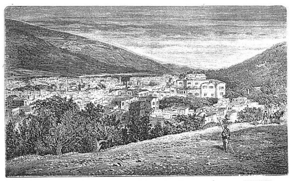
| MOUNT EBAL. | SHE'CHEM FROM THE WEST. | MOUNT GERIZIM. |
| Page 288. | ||
|
[Table of Contents] [Previous] [Next] |
J. W. McGarvey Lands of the Bible (1881) |
C H A P T E R V.
PLACES WITH SHE'CHEM AS A CENTRE.
§ I.
BETWEEN BETHEL AND SHE'CHEM.
IN the section on places in the hills of Benjamin we discussed the topography north of Jerusalem as far as Bethel. Now we continue it from the vicinity of Bethel northward as far as She'chem. The highway between these two places is in the main nothing but a stony bridle-path. In some places it is a narrow and stony lane between walls which fence in the fig-orchards and vineyards. About two miles north of Bethel a village called Ain Yebrûd' is on the left, and we are evidently entering a richer and better-cultivated district, a portion of the favored territory of Ephraim. Well-cultivated vineyards and fig-orchards, with rough stone walls around them, occupy the chief part of the surface. A short distance farther the villages of Jif'na and Ain Sinî'a lie a mile or two to the west, the latter less than a mile north of the former. Neither has a Bible history, but Jif'na is an unusually well-built village, situated on a conical and isolated hill, and it must always have been an important town in the district. The hills in every direction around are well terraced and covered with fig- and olive-trees. These trees are so abundant for miles around as to resemble an extensive forest. As we advance toward the north, and descend toward the Valley of the Robbers' Fountain, fig-trees give place entirely to olives. These are the most extensive and most carefully cultivated orchards of these two fruits anywhere to be seen in Palestine. In years gone by the natives of the villages acquired an unenviable reputation for ferocity, and the guides and muleteers who accompany the traveler through the district have many tales of horror to relate which show that they even yet pass that way with some timidity.
After passing through these groves, the road, which has been [279] continually descending for about a mile, enters into the bed of a valley called Wâdy el Harami'yeh, which derives its name from Ain el Harami'yeh, the Robbers' Fountain. The valley here runs north and south, but just in our rear, where we enter it, it turns to the west and passes off deep down between the mountains toward the Maritime Plain and the sea. It is by far the deepest valley seen near the road since leaving Jerusalem. When we have gone about a quarter of a mile up the valley we see on the left a perpendicular ledge of rock about 20 feet high, and above this the mountain slope to a height of 600 or 700 feet. From the base of this perpendicular ledge there issue several small but perennial springs of good water, and a smooth plot of ground between the cliff and the torrent-bed which drains the valley is the much frequented camping-ground of the Robbers' Fountain. Just south of the camping-ground, the space between the torrent-bed and the cliff is occupied by a very large cistern and a pool. The cistern, which was dug down into solid rock and arched over, is 50 feet long by 30 in width, and of an unknown depth, being now nearly filled with earth and rubbish. Its arch has mostly fallen in. The pool, whose northwestern corner touches the cistern, is 84 by 120 feet, and strongly built of stones laid in cement. It is now nearly full of earth, and when seen by the author it was growing a crop of wheat. The mountain just opposite, on the eastern side of the valley, forms a magnificent natural amphitheatre. It is about 1000 feet high, and is almost a perfect arc of a circle. Its steep slope is covered from base to summit with terraces, natural and artificial, the benches of which are cultivated in grain and thinly set in olive-trees.1 This place is about six miles north of Bethel and about eighteen north of Jerusalem. It is the halfway station between Jerusalem and She'chem. It evidently derived its name--Robbers' Fountain--from some tradition connecting it with the depredations of robbers, but the details of the tradition have been lost.
A ride of about four miles northward, over a path which steadily ascends out of the deep depression just left, brings the traveler to the general level again, after which, in about another mile of descent, he reaches the spring and the village of Lubbâan', the ancient Lebo'nah. A beautiful, well-watered, and well-cultivated valley descends toward this village from a southeasterly direction, and passes on toward [280] the west. It is Wâdy el Lubbâan, and it heads in the vicinity of Seilûn.
It is said of Shiloh, the place where the tabernacle stood from the days of Joshua until after the death of Eli, that it was "in a place which is on the north side of Bethel, on the east side of the highway that goeth up from Bethel to She'chem, and on the south of Lebo'nah."2 This is rather a vague description, but it answers in every particular to the site of the ancient ruin now called Seilûn, an evident corruption of Shiloh. It is about a mile east of the highway, and is reached in going north by turning to the right on the first plain making in from the east after leaving the Robbers' Fountain. It is the plain of Tûr'nûs Ay'a, with a village of the same name about a mile to the east, and it is everywhere well cultivated and productive. Another plain from the north opens into this, and on the northern edge of the latter plain are the ruins of Shiloh. They cover the summit of a smooth, rounded eminence, with a much higher ridge north of it, from which it is cut off by a deep, narrow ravine with almost perpendicular sides. The ruins consist mainly of piles of weather-worn building-stones, the remains of small but well-built stone houses. Immediately in front of them, a little lower down the hill, is a small flat-topped building, with a flight of outside steps ascending to the roof, which has been used as a mosque and previously as a chapel, and also according to Conder as a synagogue, though it is quite small for any one of the three, being only 37 feet square.3 A magnificent oak overtops it. The view to the south, the east, and the west is very fine, including level and beautiful valleys, surrounded by smoothly-rounded hills not more than 200 or 300 feet in height. In the valley to the southeast there is a well in the open field, and beyond it, on the opposite slope, are the ruins of a church, the foundations and part of the walls of which are well preserved. But that which gives the chief interest to the locality is a space artificially leveled on the northern brow of the eminence, just back of the ruins of the village, in which the tabernacle stood during its long continuance in Shiloh. It is 400 feet long from east to west, extending as far in this direction as the width of the hill would allow, and 77 feet wide. It was made by cutting down the rock along the swell of the hill to a level with the two ends of the area, and in doing so the natural rock is left from two to six feet high on each side for a considerable distance, but more on the upper side than on the lower. It is entirely certain that this escarpment was made in order to obtain [281] a level space for some purpose, and the dimensions of the space, just two feet wider than the tabernacle court, and long enough to leave a level space in front for the assembling of worshipers and victims, indicate unmistakably that it was intended to accommodate the tabernacle. There is no other spot on which the tabernacle ever stood that can be thus identified, and it is certainly remarkable that this can be, after a lapse of more than 3000 years. This is due to the fact that it was cut in the solid rock of the hill-top, where no earth could collect upon it to conceal it, and where no buildings were afterward erected to cover it with their ruins.
It is remarkable that while the book of Joshua, in describing the lands allotted to Judah and Benjamin and some of the other tribes, mentions a large number of the cities included in them, it mentions very few of those allotted to Ephraim and Manasseh, and these few are chiefly in the Maritime Plain.4 Nor is the book of Joshua alone in this singular omission, for all the books of the Old Testament are surprisingly silent in regard to the topography of the hill country occupied by these two powerful and wealthy tribes. Consequently, though many well-situated and interesting villages are scattered over the hills all the way from Bethel to She'chem, only a few of them are even mentioned in the Bible, and most of them are therefore devoid of historical interest. It may be that these tribes, being almost exclusively agricultural in their habits, lived almost entirely in small and perishable villages, and built but few towns of any importance. At any rate, we meet with no places bearing a Scriptural name, or having a Scriptural history, after leaving Shiloh, until we enter the rich and beautiful Plain of Moreh, now called Wâdy el Mûkh'nah. We enter it near its southern extremity, about five miles from She'chem, and follow it, in a direction a little east of north, until we reach the Valley of She'chem, opening to the west, and still we have not reached its northern extremity. It extends two miles farther, being seven miles long and from one and a half to two miles wide. This is probably the richest and certainly one of the most beautiful valleys in Palestine. When seen by the author it was covered chiefly with yellow grain, fully ripe and waiting for the harvest, but not a sickle had yet been thrust in. Intermingled with the broad expanses of golden grain were belts of green dur'ah, which was just high enough to almost hide the ground with its rich mantle of green. Undulating hills of moderate height and irregular swell form its eastern border, while the lofty ridge of [282] Mount Ger'izim rises abruptly from its western side, and, towering higher and higher as it extends northward, reaches its highest elevation where it suddenly breaks down by an almost perpendicular precipice into the Valley of She'chem, between it and Mount Ebal. The latter mountain rises as abruptly, and forms the remainder of the western boundary of the plain. A little more than a mile from the southern end, and on its eastern side, is the village of Awer'ta, where two tombs are shown, which are called the tombs of Eleazer and Phinehas.
This plain is first mentioned as a camping-place of Abraham when he first came into the land of Canaan,5 and in it Jacob, when he had returned from Padan-aram, bought a piece of land from the prince of She'chem. Here he resided until after the exciting scenes connected with the misfortunes of his daughter Dinah.6 There is nothing said in the Old Testament of his having dug a well there, but in the New Testament a deep well in the plain, at the foot of Mount Gerizim, was known as "Jacob's Well," and it was believed that Jacob dug it, and "drank thereof, himself and his children and his cattle."7 The well is still there. It is on the principal highway through Samaria, as the text of John requires, being only a few steps to the right of the road; and, what makes its existence remarkable, it is in the midst of a district well watered by springs and running streams, showing that some extraordinary contingency must have caused it to be dug. One of these streams, having its origin in a copious spring about a quarter of a mile distant, passes within 200 yards of the well. The very existence of the well under such circumstances is a puzzle, until we remember that Jacob, having purchased a piece of land in order to be independent of his neighbors, had equal need to become independent of them in regard to water, and therefore, to avoid depending on their springs, he must needs dig a well on his own premises. There is no ground, then, for a rational doubt that the tradition, which in the time of Christ ascribed it to Jacob, is correct.
A church was built over the well in the fourth century,8 and its water was drawn up through the floor of the church, near its eastern end. Nothing now remains of the church but its foundation-walls and the arches or vaults which supported its stone floor. The top of the vault which stood over the well has partly fallen in, and in order to reach its mouth one must climb down through the opening in this vault. The stones of the vault lie in a confused heap about the well's mouth, no [283] person having had the care to move them out of the way. The top of the well is arched over like a cistern, and a round opening is left about 20 inches in diameter. Another opening of irregular shape has been broken through it. By the light admitted through these openings one can see the wall distinctly. It is built of stones of good size, smoothly dressed, and nicely fitted together. The workmanship is like that of the wells at Beer'sheba. It is a perfect cylinder, and 7½ feet in diameter. Robinson quotes Maundrell as stating that the well, when visited by him, was 105 feet deep, and contained 15 feet of water; and another writer, who visited it in 1839 and found it 75 feet deep, with 10 or 12 feet of water.9 Captain Anderson is the only modern explorer who has actually descended it. He was let down by a rope, the untwisting of which under the tension of his weight caused him to revolve so rapidly that he fainted in the descent, and upon returning to consciousness he found himself on his back in the dry bottom of the well, looking up to the opening in the top, which appeared like a star. He found an unbroken pitcher in the bottom, which must have fallen when there was water in the well, or it would have broken. He also found the depth 75 feet, and states that it had been filled up 10 feet in the previous 10 years; but this last statement must be erroneous if the last writer quoted by Robinson made no mistake.10 This measurement was made in 1866. When visited by the author, in 1879, his tape-line touched bottom at 66 feet, showing that the process of filling up, which is the result of the custom followed by all visitors, both native and foreign, of throwing in stones to hear them strike the bottom, has been steadily going on. It is to be sincerely regretted that this practice is not checked by putting the well under proper guardianship, restoring it to its original condition, and protecting it by a suitable superstructure. It belongs to the Greek Church, and it is feared that if they improve the site, as is expected, they will not restore its original condition, but build over it another church. It is the opinion of both Anderson and Conder that it is dug through alluvial soil, and that it receives its water by infiltration; but if this is true as regards its present depth, it can scarcely be so in regard to its original depth. If restored to its original depth, it would probably hold a large quantity of water the year round; whereas now it is dry except in unusually wet winters.
About 400 yards north of the church, in the direction of Mount Ebal, is a structure known as Joseph's Tomb. It is a building of two [284] apartments, the more northern being a round vestibule, and the more southern a roofless inclosure about 25 feet square, surrounded by a wall 10 feet high. The tomb is in the latter. It is constructed in the usual style of Mohammedan tombs, about seven feet long, four feet wide at the base, and raised in the shape of a grave about three feet high in the middle. At each end is a stone pillar with an urn on its top filled with black ashes, from rags and such things that have been burned there by Jews. Small earthen lamps with oil in them are also deposited by devotees in an opening in one end of the tomb. The wall around it is a reconstruction made in 1868 by a Mr. Rogers, British consul at Damascus, and the fact is stated on a marble slab let into the wall. The probability that this is the real resting-place of the bones of Joseph is very great. His mummy, when brought up out of Egypt by Joshua, was buried in the "parcel of ground which Jacob bought of the sons of Hamor, the father of Shechem, for an hundred pieces of silver,"11 and this is that parcel of ground. True, the tomb is of Mohammedan structure and modern, but the long period of time which has elapsed has made many reconstructions of the original tomb necessary, and this may be but the last of a series; and the fact that it is not made to point toward Mecca is opposed to the supposition that it is an invention of the Moslem. But for the superstition of the Moslem, who would resent with the utmost violence any attempt at excavations into the tomb, the question whether Joseph's mummy, or any part of it, is to be found there could be settled in a few hours; and doubtless the day is coming when this will be done. It is not impossible that visitors to the Holy Land may yet gaze upon the actual body of Joseph here, and at Hebron look his father Jacob in the face. The sight would add greatly to the attractions which draw pilgrims to Palestine, and it would be a singular prolongation of that future into which Joseph looked by faith when he "made mention of the departure of the children of Israel, and gave commandment concerning his bones."12
Were a wall built from Jacob's Well to Joseph's Tomb, it would almost close up the mouth of the Valley of She'chem, which comes into the Plain of Moreh here from the west, occupying the space, about half a mile wide, between Mount Ger'izim and Mount Ebal, the latter on the north, the former on the south. There would be left, between the south end of the supposed wall and Mount Ger'izim, a space 100 or 200 yards wide, and one of about the same width between its [285] northern end and Mount Ebal. If another wall, about 100 yards farther west, were built entirely across the mouth of the valley, the southern end of it would stand in the village of Belâ'ta, a collection of hovels built of stone, and the northern end would rest on 'As'kar, a mud village at the base of Mount Ebal. It is now well settled that this latter village is the successor of the city of Sychar, mentioned in connection with the Saviour's visit to Jacob's Well, and that Sychar is not, as has long been supposed, another form of the name She'chem. It seems from Stephen's speech, in Acts, that She'chem was known to the apostles under its own proper name13 and is not to be confounded with Sychar. Moreover, this place is much better suited to the narrative than She'chem, for it is scarcely half a mile from Jacob's Well, whereas She'chem is a mile and a half distant. The statement that the city was "near to the parcel of ground that Jacob gave to his son Joseph"14 is strictly true of 'As'kar; and this agrees well with the circumstance that the woman ran without her waterpot into the city, and soon returned, followed by the people.15 There is a splendid spring of water in 'As'kar, and this might suggest the question why the woman should have gone half a mile to the deep well to draw; but the obvious answer is that she was probably at work in the plain, with the well between her and the town. This supposition must be adopted, whether we suppose her to have belonged to 'As'kar or She'chem; for had she come from the latter place she would not only have left an abundance of excellent springs behind her, but she would have passed one on her way about a quarter of a mile before she reached the well. 'As'kar may at that time have extended across the principal part of the valley, and have reached much nearer to the well than at present; for, besides the inherent probability of this, the valley contains many ruins imperfectly buried beneath its rich soil.16
We now enter the Valley of She'chem. It is a remarkable formation, being a narrow gap separating two mountain ridges just at the point where each has reached its highest elevation. Mount Ger'izim, commencing some 8 or 10 miles to the south, and gradually ascending as it extends northward, here reaches its highest elevation, and breaks down, as we have said before, by an almost perpendicular descent of 1000 feet into this valley. Mount Ebal does about the same on the opposite side, but its descent is more than 1200 feet. The gap is a complete one, for it passes through the entire range. The eastern end of the valley drains into the plain of Mûkh'nah, but the greater part [286] of it drains westward into a depression which passes on to the Plain of Sha'ron. After entering the valley from the Plain of Mûkh'nah, and riding about a quarter of a mile, we pass a large stone building on the left, used as a barracks for a regiment of Turkish soldiers. It was built in 1874. Near the corner of this building is a copious spring of cool water, which sends forth the stream mentioned above as flowing near Jacob's Well. It passes through the village of Belâta, and is then led into irrigating channels to water gardens in the vicinity of Joseph's Tomb.
Just beyond the barracks there is a sudden widening of the valley, made by a recess in the side of Mount Ger'izim, which forms a vast natural amphitheatre, and by a similar recess of almost the same dimensions exactly opposite in the side of Mount Ebal. The valley is here more than half a mile wide, and the chord of each of the amphitheatres is more than a quarter of a mile long, while the slope of each mountain from base to summit is nearly half a mile. This is unquestionably the spot in which Joshua assembled the twelve tribes and read to them the law, as directed in the 27th chapter of Deuteronomy, and as described in Joshua viii. 30-35. If it were possible, under any circumstances, for one man to read so as to be heard by such a multitude, this is the very place in which to do it. A number of travelers have tried the experiment of speaking to one another from mountain to mountain, and have succeeded with ease. The author tried the experiment of standing in the middle of the valley, with one of his companions half way up Mount Ger'izim, and the other halfway up Mount Ebal, and reading to them the curses in the 27th chapter of Deuteronomy. He was heard distinctly by the one on Mount Ger'izim and indistinctly by the one on Mount Ebal, the thick grove of olive-trees to the eastward obstructing the passage of the sound in that direction. If, therefore, the people could have stood in this vast double amphitheatre, which seems altogether probable, Joshua could have read to them without aid so that all could hear. But as he was instructed to employ the aid of Levites,17 it is probable that he had these distributed through the multitude, to take up the reading and repeat it after him sentence by sentence. However this may be, the discovery of such an auditorium in the very spot where an event of nearly 4000 years ago suggests that it might be found, while the record of the event says nothing about it, is a striking coincidence confirmatory of the Biblical narrative. [287]
From the amphitheatre to the city, a distance of about half a mile, the valley is nearly filled with olive-trees in full bearing, and the ground beneath them is cultivated in grain. The road is enlivened by the constant passage to and fro of men, women, children, and beasts of burden, while passing Turkish soldiers and officers of the garrison, some on horseback and some on foot, display their military airs and uniform. All indicate our near approach to a city of no mean pretensions.
§ II.
SHE'CHEM AND ITS ENVIRONS.
The town called She'chem in the Bible obtained under the Roman dominion the name Neapolis (New City), from the circumstance of having been rebuilt or restored. This name, in the abbreviated Arabic form of Nab'lus, it has retained to the present time,--one of the few instances in Palestine in which the Roman name of a place has permanently superseded the original name. It is 35 miles north of Jerusalem, and is situated in the valley between Mount Ger'izim and Mount Ebal, about a mile and a half west of its mouth at the Plain of Moreh. It is situated on the southern side of the valley, extending from the precipitous face of Mount Ger'izim down to the bottom of the valley and for a short distance beyond it. Westward of the town Mount Ger'izim gradually descends, the chief part of its lofty front being eastward of the town. The town is 1870 feet above the sea-level, with Ger'izim towering 1000 feet above it. It is on the watershed, springs east of the town flowing to the Jordan, those in town to the Mediterranean. Its present population is estimated by Europeans at 13,000, but by intelligent natives at 20,000. It is solidly and compactly built of stone; it is full of business activity, and it bears evident marks of recent improvement. The principal part of its ancient wall is still standing, though the town has outgrown it. The people are all Moslem except about 600 Christians, chiefly Greek, and 130 Samaritans. We have already mentioned, in Chapter VII. § IV. of Part First, the mission-work of the Baptists in this place. There is also here a German Protestant mission. In addition to the ordinary traffic of a large town of Palestine, the people are largely engaged in the manufacture of soap made from olive oil. The town is said to contain 22 soap-factories. It has a large trade with the villagers around and with the Bed'awin east of the Jordan, and it is the seat of the Turkish government for that side of the river. [288]
| ||
| MOUNT EBAL. | SHE'CHEM FROM THE WEST. | MOUNT GERIZIM. |
| Page 288. | ||
The Samaritans, only 130 of whom are left from all those who once inhabited Samaria, have a synagogue in the southwest part of the city, in which are deposited several ancient Samaritan manuscripts, among them the celebrated Samaritan Pentateuch, supposed to be one of the oldest manuscripts in existence. It is difficult to obtain a sight of the latter, as the priests are in the habit of deceiving visitors by showing them one of later date.
The town is well watered by a number of springs, and fountains of fresh water are abundant on the streets. It is said that there are 75 never-failing springs within the town and its immediate vicinity. That portion of the valley immediately north of the town is occupied by an extensive burying-ground, which reaches all the way to the foot of Mount Ebal. Below this, toward the west, the valley descends rapidly, grows narrower, is abundantly watered, and is verdant with trees and shrubs and gardens. Besides the usual fruit-trees of the country, there are here many white mulberries, whose fruit is large and sweet.
She'chem is a very ancient town, and its advantageous situation must always have made it a place of importance. It was probably not yet built when Abraham first came into Canaan. This seems to be implied in the statement that "Abram passed through the land unto the place of Sichem, unto the Plain of Moreh,"18 though the term "place" may refer to the territory belonging to Sichem rather than the place where Sichem afterwards stood. At any rate, when Jacob returned from Padan-aram it was a walled town, though its population was small.19 The ruins mentioned in the preceding section, which abound along the bed of the valley eastward of the town, show that it once stood farther east than it does now, or else that it once occupied a much larger space than at present. Its importance must always have been of a commercial rather than a military character, for it is so completely overtopped by Mount Ger'izim as to be comparatively indefensible. It was doubtless for this reason that Jeroboam, who made it the first seat of his government, soon abandoned it and chose the loftily perched Tir'zeh in preference.20
Next to Jacob's Well and Joseph's Tomb, the object of greatest historical interest about She'chem is the summit of Mount Ger'izim. It is ascended on horseback by a very steep and toilsome ride, starting from the camping-place just west of the city. (The first part of the slope up which we ride is seen in the foreground in the preceding engraving.) As we climb the steep, with our faces nearly nearly eastward, we see [289] just over the town, on the brow of the mountain, a projecting ledge called Jotham's Rock. We at once accept it, from its perfect fitness, as the spot on which Jotham stood when, by his forcible and original fable, he rebuked the She'chemites in the valley below for their cruelty and ingratitude toward his father Gideon. He must have stood on a spot whence he could be heard and seen from the valley below, and yet be out of the reach of an arrow-shot; and at the same time, he must have had a safe way of retreat when his speech was ended. The rock in question meets all of these conditions; for it stood high above the people, yet near to them, and the steep face of the mountain prevented a rapid pursuit of Jotham, while his retreat was unobstructed.21
When we stand on the summit of the mountain the Plain of Moreh lies beneath our feet on the east, and the mouth of the Valley of She'chem
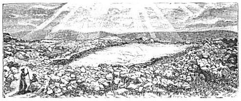 |
| SACRED ROCK OF THE SAMARITANS. |
on the north. The elevation, according to Conder, is 2849 feet above the sea-level. An extensive plateau is here covered with the ruins of ancient buildings, among which can be traced those of the church built here by Justinian, A. D. 533; of a castle with a well-preserved pool for rain-water by its side; and, as the Samaritans believe, of their temple, which once stood here, but was destroyed 130 years before Christ. They have their sacred rock, over which their temple stood, as have the Jews and the Moslem on Mount Moriah. It is seen, together with surrounding stones from ancient buildings, in the above cut. Cisterns and pavements are abundant; a Mohammedan wely stands on the eastern brow of the mountain, and the mountain's eastern slope shows the remains of ancient terraces. [290]
To the Samaritans, Mount Ger'izim continues to be, as it was in the time of Christ,22 the most sacred spot on earth. They believe that it is the exact centre of the earth, and they are persistent in believing that it is the highest mountain in the world. When Conder pointed out to their high-priest the fact that Mount Ebal, just across the valley, is obviously higher (227 feet higher), the old man replied that it appeared to be so, but it could not be so in reality, for "Mount Ger'izim is the highest mountain in the world!"23 They believe that this is the mountain on which Abraham offered Isaac, and that it is the Bethel near which Jacob saw the vision of the ladder. Here they commenced the worship of God, according to the Jewish account, by aid of a Jewish priest, who was driven from Jerusalem because he had married a daughter of Sanballat, about the close of the Old Testament history,24 and here they continue to observe the annual festivals appointed by the law of Moses. Although the Passover has never been observed according to the law by the Jews since the destruction of their temple A. D. 70, it has continued through all the Christian centuries to be observed by the Samaritans on Mount Ger'izim, and it is observed by the remnant of them to the present day. At the time of its annual recurrence the entire Samaritan population of Nab'lus go to the mountain-top and live in tents for seven days. They slay seven lambs precisely at sunset on the evening of the appointed day (the first full moon after the vernal equinox), roast their bodies whole, eat them with unleavened bread about midnight, and spend the last four hours of the night in prayer. Dean Stanley was so fortunate as to be present at this celebration during his second visit to Palestine, in 1862, and he gives a very interesting account of it in an appendix to the first volume of his "Lectures on the Jewish Church." The editor of Baedeker's Guide-Book also witnessed it in 1869, and gives substantially the same account of the proceedings.25 When the author was there, May 29, 1879, he saw the recently charred bones of the roasted lambs scattered about the place of sacrifice, but he was more than a month too late to witness the festival. The cut on the following page represents these people as they watch the setting sun in the evening of the Passover.
The view from the summit of Mount Ger'izim is widespread and magnificent, though not so much so as that from the higher summit of Mount Ebal. The southern face of the latter mountain, that seen [291] from Mount Ger'izim and the Valley of She'chem, is covered with a thick growth of cactus, except in a few spots where the slope is gradual
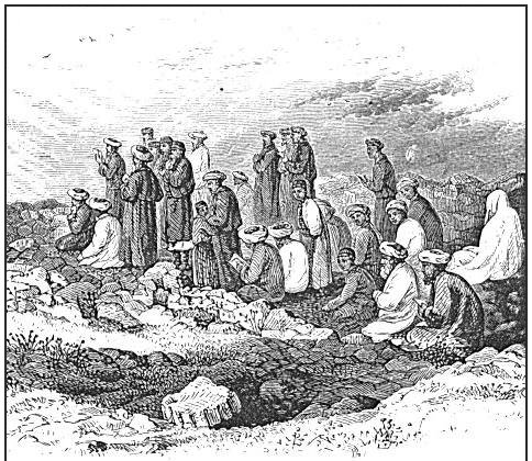 |
| SAMARITANS AT WORSHIP ON MOUNT GER'IZIM. |
and occupied by terraces cultivated in grain. The summit of this mountain, according to Conder, is 3076 feet above the sea. It is the highest point in Palestine north of the mountains near Hebron and south of northern Galilee.
On a lower mountain, a short distance to the north of Mount Ebal, is Tolûsa, the Tirzah of Scripture, which was the second place chosen by Jeroboam as the seat of his kingdom, and which continued to be the capital of the northern kingdom until Omri bought the Hill of Samaria and transferred the seat of power to that spot.26
She'chem is the most convenient place from which to make an excursion to "Ænon near to Salim," where John baptized when he left the Jordan. Starting east from the city, and on reaching the Plain of [292] Moreh leaving Joseph's Tomb on the right, and, passing through the village of As'kar (Sychar), we follow the Damascus road, which runs north along the eastern foot of Mount Ebal, with the Plain of Moreh on the right. About two miles north of As'kar the Plain of Moreh terminates, and a very lofty mountain crowned with a white wely rises abruptly from its northern extremity. Just before reaching the northwestern corner of the plain we have opposite to us, on a slope at the northeastern curve of the plain, the village of Salim (Salem), near to which was the baptizing-place of Ænon.27 The most direct and easiest route to the latter place crosses the plain and passes through Salem; but the author, preferring to trace the waters from their fountain-head, continued along the Damascus road, following the course of Wâd'y Bedân', about three miles north of the end of the Plain of Moreh. These three miles pass over a very rugged road. The road runs into and crosses Wâd'y Bedân' in the midst of a group of four water-mills, which do the chief part of the grinding for She'chem and the surrounding country. By continuing on the Damascus road until another mountain-spur immediately north is crossed, we may enter into the head of Wâd'y Far'ah; but as that wâd'y unites with Wâd'y Bedân' about two miles below the mills just mentioned, it is better to turn down the latter wâd'y and follow its course. It runs almost directly to the east. In the course of these two miles we pass eight more water-mills, the last at the junction of the two wad'ies, and supplied by a race from Wâd'y Far'ah. The stream in the latter wad'y is the larger of the two, and from the point of junction the united waters bear the name of Wâd'y Far'ah. About four miles below this the bed of the wâd'y, which has been very narrow thus far, and is in no place wide enough to accommodate a large multitude, such as assembled to hear the preaching of John, suddenly expands on the northern side of the stream to about a mile in width, with a gradual upward slope toward the north, and extends eastward with the stream along its southern side for about two miles. No prettier mountain valley is seen in Palestine, and none more suitable for John's purpose. The stream for about five miles of its course, as traced by the author, is continuously fringed with oleanders, which were then in bloom. Our path crossed the stream repeatedly, and we found it abounding in pools from two to three feet deep, though at an unusually low stage of water on account of the exceptionally dry winter which had preceded. The stream is perennial, and flows thence to the Jordan, increasing in volume as it [293] descends through its mountain pass. It enters the Jordan a short distance south of the Dam'ieh ford.
To Lieutenant Conder, the first European who carefully examined the eastern hills of Samaria, belongs the credit of identifying this locality, and it is due him that we here introduce his own description of it:
"The head-springs are found in an open valley surrounded by desolate and shapeless hills. The water gushes out over a stony bed, and flows rapidly down in a fine stream surrounded by bushes of oleander. The supply is perennial, and a continuous succession of little springs occurs along the bed of the valley, so that the current becomes the principal western affluent of Jordan south of the Vale of Jezreel. The valley is open in most parts of its course, and we find the two requisites for the scene of the baptism of a huge multitude,--an open space and abundance of water. Not only does the name Salem occur in the village three miles south of the valley, but the name Æ'non, signifying 'springs,' is recognizable at the village of Ainun', four miles north of the stream. There is only one other place of the latter name in Palestine, Beit Ainun', near Hebron; but this is a place that has no very fine supply of water and no Salem near it. On the other hand, there are many other Salems all over Palestine, but none of them has an Ænon near it. The site of Wâd'y Far'ah is the only one where all the requisites are met,--the two names, the fine water supply, the proximity of the desert, and the open character of the ground."28
As Conder suggests, this Wâd'y Far'ah was the route of Jacob and his caravan in their journey from the Jordan through the mountains up to She'chem;29 and it was also that of the Syrian army on their retreat from Samaria under a false alarm.30
§ III.
PLACES WEST AND NORTH OF SHE'CHEM.
That part of the Valley of She'chem which extends west of the city descends rapidly at first, then more gradually, and makes its way nearly northwest through the mountains to the Plain of Sha'ron. It was the highway from She'chem to Samaria, Cæsarea, Lydda, and Joppa. But the present road to Samaria leaves the valley after following it for three or four miles, crosses a ridge to the north, and descends into the Valley of Samaria on its eastern side. Samaria is eight miles from [294] She'chem by the road (six in an air-line) and due northwest. Its situation attests the military skill of Omri, the King of Israel, who bought the hill and built the city for the capital of his kingdom.31 It also accounts for the fact that though the city was three times besieged within the Bible period by an overpowering army, it was never taken but once, and then after a siege of three years.32 It is to the confidence which its inhabitants reposed in its strength that Amos alluded when he said, "Woe to them who are at ease in Zion, and trust in the mountain of Samaria."33 It was built on an isolated hill about 400 feet high, completely surrounded by an almost circular valley, and this again by a circle of mountains nearly all higher than Samaria. Its site might be compared to that of a conical swell in the centre of a deep saucer. The hill is ascended from the northeast by a steep slope, and the modern village, with a large and well-preserved church of the crusading period, is on the northeastern brow of the hill. The summit is now set in olive-trees and cultivated in grain. Terraces run around the hill from top to bottom, and on the second terrace from the top
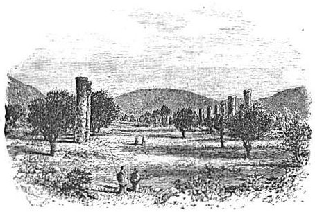 |
| HEROD'S COLONNADE AT SAMARIA. |
stand the remaining pillars of a colonnade built by Herod the Great, which once extended around the hill for a distance of 1000 yards. The terrace is about 50 feet wide, and the columns, of which about 80 [295] are still standing, and many others are lying prostrate and broken, are 16 feet high. They are made of hard limestone. There are many other relics of ancient structures on the slopes of the hill, and among them one on the northern side, consisting of about a dozen columns, forming a quadrangle, the probable remains of a temple erected by Herod in honor of Augustus Cæsar. He rebuilt the city, adorned it with magnificent works, and called it Sebaste, the Greek word for Augustus, and it has retained that name in a corrupted form to the present day, the Ar'abs calling it Sebûs'-ti-yeh. Its summit is 1542 feet above the sea, and the highest point is near the southern brow. Standing there, the entire wall of surrounding mountains and the basin of the surrounding valley can be distinctly seen, and over the lower hill to the southwest the view extends to the Plain of Sha'ron and the sea. The valley is widest toward the south and west, where it is about two miles wide. At the southeast curve of this valley the Valley of She'chem enters it, and at the southwest curve there is a broad opening through the hills, by which that valley passes on westward toward the sea. The author's party traveled down that valley on their way to Cæsarea, and they saw along its floor some of the best-preserved pieces of ancient paved road in all Palestine. It was doubtless in the valley immediately south of Samaria that the Syrians were encamped when they thought they heard the Egyptians and the Hittites coming upon them, and it was up that gap opening toward the sea that the enemy appeared to come. The Syrian retreat was toward the Jordan, and it probably led them up the Valley of She'chem, east of their camp and past the city of She'chem.34
Many villages, the sites of ancient towns, are perched on the hills round about Samaria, as they are in every part of the hill country, but, for a cause mentioned above (page 282), few in this portion of the country have any Bible history.
About twelve miles by the road a little east of north from Samaria, and about four miles farther from She'chem, is Dothan, the place near which Joseph was sold by his brethren, and in which was the prophet Elisha when it was surrounded by Syrian soldiers for the purpose of capturing him.35 In riding to it from either place many villages are passed, and some beautiful valleys. It is still known under the name Tell Dothan' (the heap of Dothan). The site of the town is a hill about 200 feet high, isolated on every side except the north, where a narrow saddle about 100 feet high connects it with a still higher hill in that [296] direction. On the summit is a plateau of about 40 acres, which has been artificially leveled. Toward the eastern side are some ruins of buildings that were constructed of good limestone, while the remainder of the surface is dotted with heaps of small stones from cheaper houses. All the exposed soil is cultivated in grain. The slope of the hill on every side except the north is too steep for ascent on horseback. To the south about a mile and to the west about five miles there stretches a rich and beautiful valley, from one to one and a half miles wide, all cultivated in grain, and bordered by hills of moderate height. The word Dothan means two wells, and there they are in the valley south of the village, one a little to the right and the other to the left. When seen by the author flocks of goats and sheep were being watered at the more eastern, and at the other, about 100 yards to the west, a horsepower water-wheel was in motion, throwing water into a plastered reservoir about 30 feet square and 3½ feet deep, in which men were washing a flock of sheep preparatory to shearing them. From the reservoir water also ran in an irrigating channel to support a fine garden of cucumbers, onions, and other vegetables below. The principal thoroughfare from the north in the direction of the Plain of Sha'ron, the very road which the Ishmaelite caravan to which Joseph was sold was traveling, passes along the western foot of the hill, and Captain Wilson found in the plain a number of jug-shaped cisterns answering to the pit in which Joseph was placed. Everything corresponds precisely to the scene of Joseph's sale, and not less so to that of the attempted arrest of Elisha. The mountain that was full of horses and chariots of fire to the opened eyes of Elisha's servant stands around on every side, and is not far away except to the west. [297]
[LOB 279-297]
|
[Table of Contents] [Previous] [Next] |
J. W. McGarvey Lands of the Bible (1881) |
|
Back to BibleStudyGuide.org. These files are public domain. This electronic edition was downloaded from the Restoration Movement Texts. |